Getting Started
Last revision 2026/06/26
介绍GNSS定位基础与GPS/BDS/GLONASS系统,说明RTK实时动态定位的数据传输流程,解析NMEA 0183 GGA语句各字段含义。通过“Docs → Tutorials → Projects → SKU → Category”路径,引导用户从原理入门,到选择高精度定位模块并应用于测量、制图和工程放样等项目。
1. Basics of Positioning
1.1 Common Positioning Systems
GPS
Basic GPS positioning uses four satellites to determine 3D coordinates. Signal delays through the ionosphere/troposphere cause errors (~10m).
GNSS
Global Navigation Satellite System (GNSS) provides global 3D position, velocity, and time data via satellite radio navigation.
BDS (China)
BeiDou Navigation Satellite System offers decimeter/cm-level accuracy, 0.2 m/s velocity precision, and 10 ns timing accuracy.
GPS (USA)
Global Positioning System delivers global location, speed, and time data.
GLONASS (Russia)
Russia’s global satellite navigation system, similar to GPS.
Galileo (EU)
EU’s global satellite navigation system.
QZSS (Japan)
Quasi-Zenith Satellite System enhances GPS in the Pacific region, especially in urban canyons.
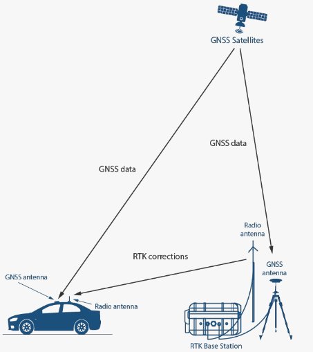
RTK
Real Time Kinematic (RTK) uses carrier-phase differential measurements. A base station transmits correction data (RTCM) to rovers for real-time cm-level accuracy.
1.2 Data Transmission Diagram
1.3 Applications
- Control surveys (e.g., engineering, topography)
- Topographic mapping
- Construction staking
1.4 NMEA Data Parsing
Modules output NMEA 0183 messages (e.g., RMC, GGA). Example GGA data: $GNGGA,063924.000,3037.643956,N,10348.010829,E,5,34,0.46,507.909,M,-32.181,M,1.0,3335*76
| Field | Name | Description | Example |
|---|---|---|---|
| 0 | Identifier | Start character ($) |
$ |
| 1 | System | $GP (GPS), $GL (GLONASS), $GN (GNSS) |
$GNGGA |
| 2 | Sentence ID | GGA (Global Positioning System Fix Data) |
GGA |
| 3 | UTC Time | hhmmss.sss |
063924.000 |
| 4 | Latitude | ddmm.mmmmmm |
3037.643956 |
| 5 | N/S Indicator | N (North), S (South) |
N |
| 6 | Longitude | dddmm.mmmmmm |
10348.010829 |
| 7 | E/W Indicator | E (East), W (West) |
E |
| 8 | Position Fix | 0=Invalid, 1=GPS, 2=DGPS, 4=RTK Fixed, 5=RTK Float |
5 |
| 9 | Satellites Used | Number of satellites | 34 |
| 10 | HDOP | Horizontal Dilution of Precision (lower = better) | 0.46 |
| 11 | MSL Altitude | Meters above Mean Sea Level | 507.909 |
| 12 | Units | M (meters) |
M |
| 13 | Geoid Separation | Geoid height above/below WGS84 ellipsoid (m) | -32.181 |
| 14 | Separation Units | M (meters) |
M |
| 15 | Differential Age | Age of RTK corrections (valid for RTK only) | 1.0 |
| 16 | Base Station ID | Reference station ID | 3335 |
| 17 | Checksum | *+ hex value |
*76 |
Was this article helpful?