Getting Started
Last revision 2026/06/30
Starting with the basics of GPS/GNSS and the principles of RTK centimeter-level positioning, this book gradually analyzes the RTK data link and the NMEA 0183 GGA statement fields.
1. Basics of Positioning
1.1 Common Positioning Systems
GPS
Basic GPS positioning uses four satellites to determine 3D coordinates. Signal delays through the ionosphere/troposphere cause errors (~10m).
GNSS
Global Navigation Satellite System (GNSS) provides global 3D position, velocity, and time data via satellite radio navigation.
BDS (China)
BeiDou Navigation Satellite System offers decimeter/cm-level accuracy, 0.2 m/s velocity precision, and 10 ns timing accuracy.
GPS (USA)
Global Positioning System delivers global location, speed, and time data.
GLONASS (Russia)
Russia’s global satellite navigation system, similar to GPS.
Galileo (EU)
EU’s global satellite navigation system.
QZSS (Japan)
Quasi-Zenith Satellite System enhances GPS in the Pacific region, especially in urban canyons.
RTK
Real Time Kinematic (RTK) uses carrier-phase differential measurements. A base station transmits correction data (RTCM) to rovers for real-time cm-level accuracy.
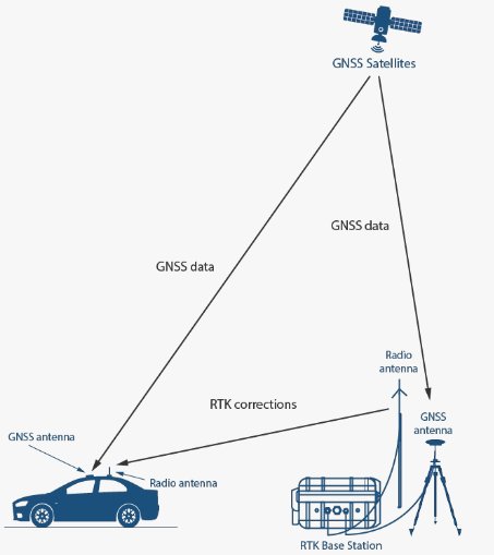
1.2 Data Transmission Diagram
1.3 Applications
- Control surveys (e.g., engineering, topography)
- Topographic mapping
- Construction staking
1.4 NMEA Data Parsing
Modules output NMEA 0183 messages (e.g., RMC, GGA). Example GGA data: $GNGGA,063924.000,3037.643956,N,10348.010829,E,5,34,0.46,507.909,M,-32.181,M,1.0,3335*76
| Field | Name | Description | Example |
|---|---|---|---|
| 0 | Identifier | Start character ($) |
$ |
| 1 | System | $GP (GPS), $GL (GLONASS), $GN (GNSS) |
$GNGGA |
| 2 | Sentence ID | GGA (Global Positioning System Fix Data) |
GGA |
| 3 | UTC Time | hhmmss.sss |
063924.000 |
| 4 | Latitude | ddmm.mmmmmm |
3037.643956 |
| 5 | N/S Indicator | N (North), S (South) |
N |
| 6 | Longitude | dddmm.mmmmmm |
10348.010829 |
| 7 | E/W Indicator | E (East), W (West) |
E |
| 8 | Position Fix | 0=Invalid, 1=GPS, 2=DGPS, 4=RTK Fixed, 5=RTK Float |
5 |
| 9 | Satellites Used | Number of satellites | 34 |
| 10 | HDOP | Horizontal Dilution of Precision (lower = better) | 0.46 |
| 11 | MSL Altitude | Meters above Mean Sea Level | 507.909 |
| 12 | Units | M (meters) |
M |
| 13 | Geoid Separation | Geoid height above/below WGS84 ellipsoid (m) | -32.181 |
| 14 | Separation Units | M (meters) |
M |
| 15 | Differential Age | Age of RTK corrections (valid for RTK only) | 1.0 |
| 16 | Base Station ID | Reference station ID | 3335 |
| 17 | Checksum | *+ hex value |
*76 |
Was this article helpful?