Gravity: GNSS-RTK High Precision Positioning Kit-EU

SKU: KIT0198-EU

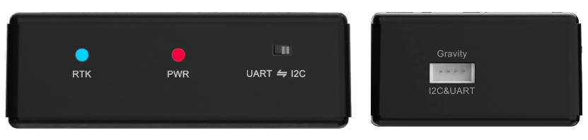
DFRobot’s entry-level RTK positioning kit offers centimeter-level accuracy within 1.5KM in open areas. It uses Quectel’s LC29HDA rover and LC29HBS base modules, plus LoRa wireless transmission. Both are L1/L5 dual-frequency, supporting GPS, GLONASS, Galileo, BDS, QZSS. The kit has a pre-configured data link (no user setup), ideal for RTK learning, device tracking, trajectory mapping, and personnel positioning.

Overview of GNSS-RTK High Precision Positioning Kit
  • Docs
  • Tech Specs
  • 1. Getting StartedNew

    介绍GNSS定位基础与GPS/BDS/GLONASS系统,说明RTK实时动态定位的数据传输流程,解析NMEA 0183 GGA语句各字段含义。

    2. Example Code for Arduino-Reading Data via UART

    Tutorial explains Arduino UNO UART GNSS RTK wiring, I2C baud rate configuration, and UART NMEA data reading. Includes sample code to get latitude, longitude, RTK fix status via UART using an RTK LoRa library.

    3. Example Code for Arduino-Reading NMEA Data via I2C Protocol

    Read NMEA data from the GNSS-RTK kit using the I2C protocol with Arduino IDE.

    4. Example Code for Raspberry Pi-UART Tutorial

    Read GNSS data from the GNSS-RTK kit using the UART protocol with Raspberry Pi.

    5. Example Code for Raspberry Pi-I2C Tutorial

    Read GNSS data from the GNSS-RTK kit using the I2C protocol with Raspberry Pi.

    Reference

    文档聚焦GNSS module API,涵盖getUTC/getDate时间日期接口、getLat/getLon经纬度解析、getAlt/getHdop精度信息、差分GPS参数,以及setModule切换4G/Lora、波特率配置与getGnssMessage数据获取

    1. Specification

    1.1 Base Station

    Parameter Details
    Power Supply Type-C
    Terminal: 5~10V
    GNSS Antenna Interface SMA
    Reception Bands GPS/QZSS: L1 C/A, L5
    GLONASS: L1
    Galileo: E1, E5a
    BDS: B1I, B2a
    Default Constellations GPS + GLONASS + Galileo + BDS + QZSS
    Concurrent Constellations 4 + QGNSS
    Function Base station
    Sensitivity Acquisition: -147 dBm
    Tracking: -165 dBm
    Reacquisition: -159 dBm
    Dynamic Performance Max Altitude: 10000 m
    Max Velocity: 500 m/s
    Max Acceleration: 4g
    Raw Data Update Rate 1 Hz
    Protocol NMEA 0183 / RTCM 3.x

    1.2 Mobile Station (RTK Mobile)

    Parameter Details
    Operating Voltage 3.3V~5V
    Output Signal I2C/UART
    Antenna Interface SMA
    Reception Bands GPS/QZSS: L1 C/A, L5
    GLONASS: L1
    Galileo: E1, E5a
    BDS: B1I, B2a
    Default Constellations GPS + GLONASS + Galileo + BDS + QZSS
    Concurrent Constellations 4 + QGNSS
    SBAS WAAS, EGNOS, MSAS, GAGAN
    Function RTK
    Horizontal Positioning Accuracy Autonomous: 1 m
    RTK: 5 cm + 1 ppm
    Velocity Accuracy 0.03 m/s
    1PPS Accuracy 20 ns
    RTK Convergence Time <10 s
    Sensitivity Acquisition: -145 dBm
    Tracking: -165 dBm
    Reacquisition: -157 dBm
    Dynamic Performance Max Altitude: 10000 m
    Max Velocity: 500 m/s
    Max Acceleration: 4g
    Navigation Update Rate(RTK) 1 Hz
    Raw Data Update Rate(GNSS) 1 Hz
    Protocol NMEA 0183 / RTCM 3.x
    LoRa Parameters RF Chip Semtech: LLCC68
    Operating Frequency: 868MHz
    Modulation: LoRa Spread Spectrum
    Max Transmit Power: 22dBm
    Receiver Sensitivity: -129dBm
    Weight 700g

    2. Appearance and Interface

    2.1 Mobile Station

    Mobile

    Name Description
    RTK RTK status LED: Blinks at 1Hz for state 5 (positioning); Steady for state 4; Off for other states.
    PWR Power indicator
    UART I2C Toggle switch for UART/I2C communication interface
    Gravity I2C&UART Gravity interface for data output

    2.2 Base Station

    Base Station

    Name Description
    Type-C Type-C power interface
    PWR Power indicator
    PWR IN External terminal power (5~10V)

    3. Product Features

    • LoRa Data Transmission: Utilizes LoRa wireless technology for stable, long-range, and low-power communication of RTCM correction data between the base station and rover(s).

    • User-Friendly: Designed for ease of use with a pre-configured data link, enabling rapid setup and operation right out of the box.

    • Low Cost of Use: Provides an accessible entry point into high-precision positioning technology, minimizing initial investment and complexity.

    • Centimeter-Level Accuracy in Open Areas: Achieves high-precision centimeter-level positioning under optimal open-sky conditions.

    • Single Base Station Supports Multiple Mobile: One base station can broadcast correction data to several Mobile units simultaneously, improving efficiency and scalability.

    Was this article helpful?

    TOP